


選擇品牌

-
 Asynt
Asynt
-
 AstroNova
-
 AOiP
AOiP
-
 ADASH
ADASH
-
 Amptek
-
 Automatic Research
-
 AWSensors
-
 AARONIA AG
-
 BASI
BASI
-
 CALMET
-
 DV Power
-
 DANATRONICS
-
 Dioxide Materials
-
 ED & D
-
 ELVEFLOW
-
 ECH
ECH
-
 Elsys
Elsys
-
 EA Technology
-
 Enapter
-
 Electrothermal
-
 Enervac
-
 EL-CELL
-
 ENERGY SUPPORT
-
 FASTEC
-
 GMW
GMW
-
 Gaskatel
-
 GIUSSANI
-
 Globecore
-
 GRZ
GRZ
-
 HVPD
HVPD
-
 HIGH SENSE SOLUTIONSHTW
-
 HUBER
HUBER
-
 IVIUM
IVIUM
-
 Ida
Ida
-
 Instytut Fotonowy
-
 JGG
JGG
-
 Jacomex
-
 Jenway
-
 Kocos
Kocos
-
 KEHUA TECH
-
 micrux
-
 Metrel
-
 Microrad
-
 METERTEST
-
 ndb
ndb
-
 Norecs
-
 Novocontrol
-
 Neware
-
 OKOndt Group
-
 OZM
OZM
-
 Pine Research
-
 Pinflow
-
 Redoxme
-
 SATIR
SATIR
-
 Sonel
Sonel
-
 Serstech
-
 SDT
SDT
-
 SENSIA
-
 SIKA
SIKA
-
 SMC
SMC
-
 TANDELTA
-
 TENTECH
-
 Turnkey Instruments
-
 VacCoat
-
 Zurich Instruments
- Asynt
- AstroNova
- AOiP
- ADASH
- Amptek
- Automatic Research
- AWSensors
- AARONIA AG
- BASI
- CALMET
- DV Power
- DANATRONICS
- Dioxide Materials
- ED & D
- ELVEFLOW
- ECH
- Elsys
- EA Technology
- Enapter
- Electrothermal
- Enervac
- EL-CELL
- ENERGY SUPPORT
- FASTEC
- GMW
- Gaskatel
- GIUSSANI
- Globecore
- GRZ
- HVPD
- HIGH SENSE SOLUTIONSHTW
- HUBER
- IVIUM
- Ida
- Instytut Fotonowy
- JGG
- Jacomex
- Jenway
- Kocos
- KEHUA TECH
- micrux
- Metrel
- Microrad
- METERTEST
- ndb
- Norecs
- Novocontrol
- Neware
- OKOndt Group
- OZM
- Pine Research
- Pinflow
- Redoxme
- SATIR
- Sonel
- Serstech
- SDT
- SENSIA
- SIKA
- SMC
- TANDELTA
- TENTECH
- Turnkey Instruments
- VacCoat
- Zurich Instruments

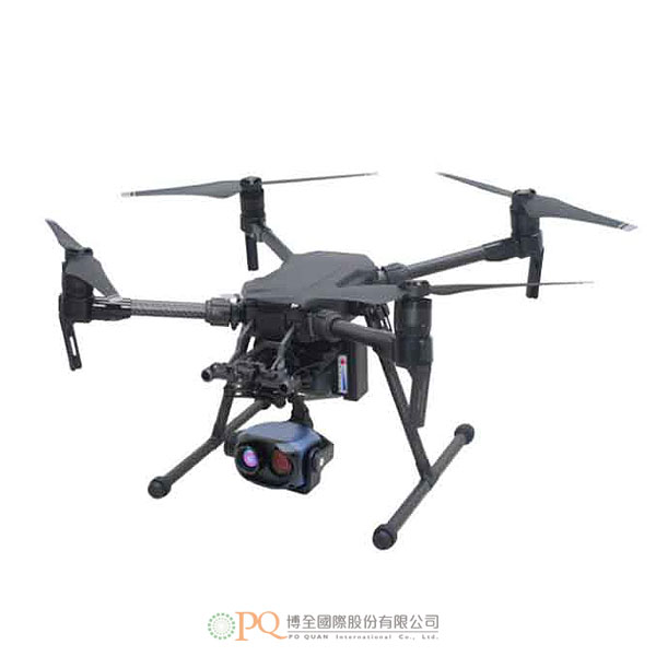
多重應用無人機熱像儀系統
SATIR Thermal Imaging UAV Drone Systems 型號:640-PSATIR熱成像無人機系統,它將最好的熱成像核心與高質量製造的無人機系統相結合。無人機系統支持HDMI&SD視頻信號。具有高增益平板定向天線;傳輸距離可達10km。 SATIR 熱成像無人機系統可用於許多不同的應用,例如搜索和救援、農業調查和電力調查。
-
SATIR熱成像無人機系統,它將最好的熱成像核心與高質量製造的無人機系統相結合。無人機系統支持HDMI&SD視頻信號。具有高增益平板定向天線;傳輸距離可達10km。 SATIR 熱成像無人機系統可用於許多不同的應用,例如搜索和救援、農業調查和電力調查。
-
尺寸 887x880x378 mm(展開)
716x220x236(折疊)最大起飛重量 6.14公斤 最大有效載荷 2.34kg(標準電池) 1.61kg(選配電池) 最大水平速度 P 模式:17 m/s,S 模式/A 模式:23 m/s 最長飛行時間(標準電池) 27 分鐘(無有效載荷),13 分鐘(起飛重量 6.34 公斤) 最長飛行時間(可選電池) 38 分鐘(無有效載荷),24 分鐘,(起飛重量 6.14kg) 海平面以上的最大服務上限 3000 m 最大抗風能力 10米/秒 防水能力 IP4 熱靈敏度 0.05°C (30°C) 光學對焦 50m,電動對焦,自動對焦 數位變倍 4x,8x,16x 探測器類型 UFPA 640x480 圖像頻率 50Hz/60Hz 光譜範圍 7-14um 視場 12°x9° 空間分辨率 (IFOV) 0.34mrad 溫度範圍 -20°C ~+150°C 準確度 讀數的 ±2 或 ±2 最大溫度自動跟蹤 自動捕獲最高溫度,並實時顯示數據 GPS 位置(選配) GPS地理坐標信息和紅外數據實時疊加,同步記錄 圖片展示 複合視頻 NTSC/PAL 調色板 白熱/黑熱/鐵 工作環境條件 工作溫度範圍 -20°C - 50°C 儲存溫度範圍 -40°C - 70°C 濕度 運行和存儲 10% 到 95%,無冷凝 雲台 雲台控制精度 ±0.01° 運動範圍 俯仰-90~+30°C,航向±150°,橫滾±25° 控制界面 PWM/5-BUS/串口 貯存 16 位全輻射紅外溫度數據存儲到 SD 卡 電壓 工作電壓 11-50V 平均功耗 6W 物理特性 尺寸 112x61x72mm 重量 ≤325g(不含雲台);≤660g(含3個穩定雲台) -
The UAV 640 P has a UFPA 640x480 detector which is a high-quality detector which will deliver clear, crisp thermal images and video to the end-user. It has electric and auto focus up to 50m. The FOV is 12°x9° and spatial resolution (IFOV) of 0.34 mrad. It has a measurement temperature range of -20°C ~+150°C with an accuracy of ±2 or ±2 of reading.
-
Dimensions 887x880x378 mm (unfold)
716x220x236 (fold)Max take off weight 6.14kg Max payload 2.34kg (standard battery) 1.61kg (optional battery) Max Horizontal Speed P mode: 17 m/s, 5 mode/A mode: 23 m/s Max Flight time (standard battery) 27 min (No payload), 13 min (take off weight 6.34kg) Max Flight time (optional battery) 38 min (no payload), 24 min, (take off weight 6.14kg) Max Service ceiling above sea level 1.86mi (3000m) Max Wind Resistance 10m/s Max Rain Resistance IP4 Thermal Sensitivity 0.05°C (30 C) Optical Focus 50m,electric focus, auto focus Digital Zoom 4x,8x,16x Detector Type UFPA 640x480 Image Frequency 50Hz/60hz Spectral Range 7-14um FOV 12°x9° Spatial Resolution (IFOV) 0.34mrad Temperature Range -20°C ~+150°C Accuracy ±2 or ±2 of reading Max. temp automatically tracking Automatically capturing max. temp and showing specific data in display in real-time GPS Position (Optional) GPS geographic coordinate information and infrared data real-time overlay,
synchronous recordImage Presentation Composite Video NTSC/PAL Palette White hot/Black Hot/Iron Environmental Specifications Operating temp.range -20°C - 50°C Storage temp. range -40°C - 70°C Humidity Operating and storage 10% to 95%, non-condensing Gimbal Gimbal control accuracy ±0.01° Movement range pitch-90~+30°C, course ±150°,roll ±25° Control Interface PWM/5-BUS/Serial port Storage 16 bit full radiometric infrared temp.data storage into SD card Voltage Working Voltage 11-50V Average Power Consumption 6W Physical Characteristics Size 112x61x72mm Weight ≤325g (excluding gimbal) ; ≤660g (including 3 stablised gimbal)